Equipment & Technology
Industry-Leading Tools for Precision Survey Results
We invest in top-tier survey equipment to ensure accuracy, speed, and reliability on every project. Our hardware and software combination delivers results that meet the stringent requirements of government departments and private developers alike.
Equipment quality directly impacts survey accuracy. That's why Das R&B Services uses only professional-grade instruments from established manufacturers, regularly calibrated and maintained to factory specifications.
Survey Hardware
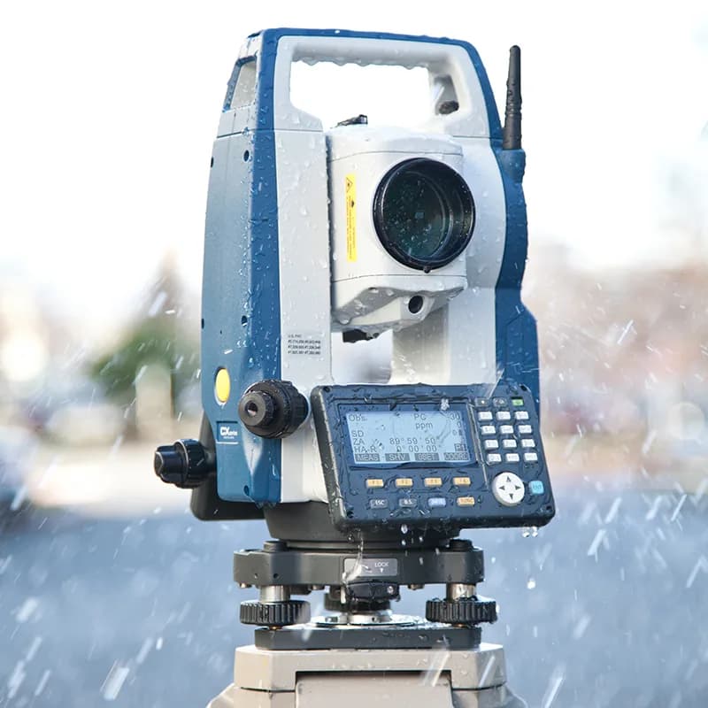
SOKKIA CX-105 Total Station
Our primary instrument for high-precision topographic and construction surveys. The CX-105 delivers exceptional accuracy with robust performance in field conditions typical of Odisha's project sites.
Angle Measurement
- Accuracy: 5" (1.5 mgon)
- Method: Absolute rotary encoder
- Compensation: Dual-axis, ±4' range
Distance Measurement
- Reflectorless: 500m
- Prism (single): 5,000m
- Accuracy: ±(2mm + 2ppm × D)

SOKKIA CX-65 Total Station
Backup and parallel operation unit for multi-team deployments and redundancy on critical projects. The CX-65 ensures we can continue operations even if primary equipment requires service.
5"
Angle Accuracy
300m
Reflectorless
4,000m
Prism Range

DGPS Receiver
Differential GPS for establishing ground control points with centimeter-level accuracy across large areas. Essential for control network establishment and large-scale mapping projects.
±10mm
Horizontal Accuracy
±15mm
Vertical Accuracy
GPS+
GLONASS
RTK
Capable
Support Equipment
Prism Sets
Tripods
Ranging Poles
Leveling Instruments
Measuring Tapes
Field Computers
Software Capabilities
Professional Tools for Data Processing & Deliverables

ESurvey CADD
Our primary software platform for survey data processing. This comprehensive package handles everything from raw data import to final deliverable generation.
Traverse Processing
- • Compass rule
- • Transit rule
- • Least squares
Contour Generation
- • TIN modeling
- • Smoothing
- • Label control
Volume Calculations
- • Grid method
- • Cross-section
- • DTM comparison
CAD Export
- • DWG format
- • DXF format
- • PDF plots
Data Formats We Deliver
dwg
AutoCAD native format
dxf
Universal CAD exchange
Print-ready plots
csv
Coordinate listings
kml
Google Earth
Ready to Start Your Project?
Get a free consultation and detailed quote for your survey requirements